datasette-maplibre 0.1a0 adds MapLibre and OpenFreeMap maps to Datasette
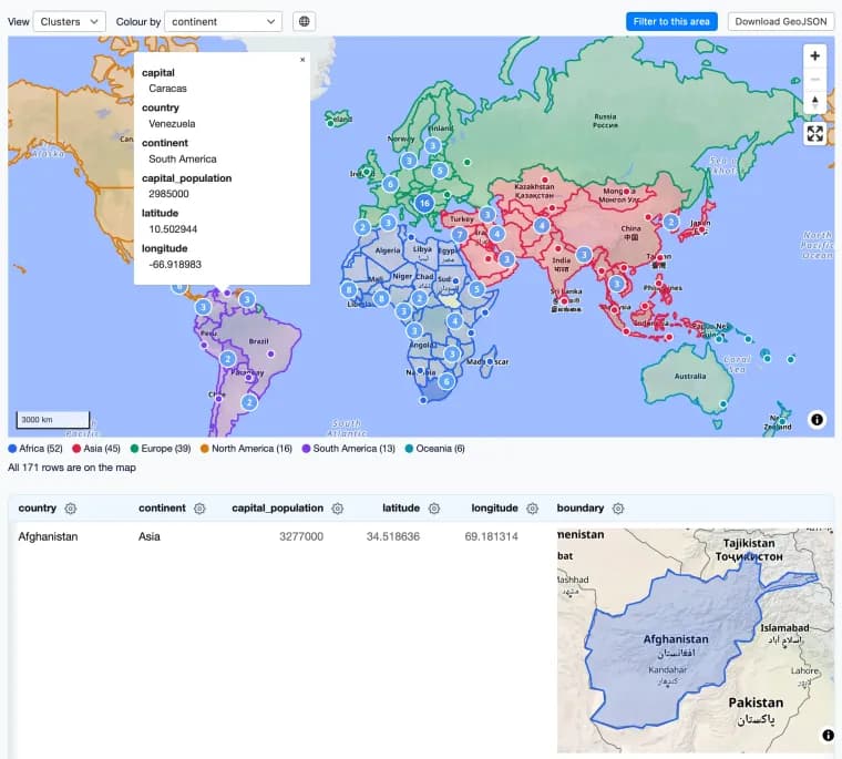
On 15 November 2026 Simon Willison announced datasette-maplibre 0.1a0, a new plugin for Datasette, the data exploration tool. He calls it the first new Datasette geospatial plugin in quite a while. It combines the MapLibre GL library with OpenFreeMap, the free vector map server operated by Zsolt Ero. Willison adds that readers should sponsor Ero on GitHub.
Willison writes that he built most of the plugin with a single prompt to Claude Fable 5.2. The prompt told Claude to look at the existing datasette-cluster-map and datasette-leaflet-geojson plugins, then at a local file, ~/dev/tools/openfreemap-demo.html. After that Claude was to build a brand new Datasette plugin that uses maplibreGL and openfreemap and combines the features of those two plugins. The prompt ended by asking Claude to be creative and think outside the box for other useful features the plugin might have.
That creativity instruction, Willison says, produced a few neat ideas. His favorite is that the plugin displays SVG previews of GeoJSON shapes, then loads a WebGL preview only when they scroll into view.
He also had Claude build a comprehensive demo that works in the latest Datasette Lite. The post links to it: opening the link loads the plugin and a demo database in the browser via Pyodide and WebAssembly. Willison singles out one demo page that shows both GeoJSON shapes and lat/lon points on the same map.
Key facts
- Simon Willison announced datasette-maplibre 0.1a0 on 15 November 2026, a Datasette geospatial plugin combining MapLibre GL with OpenFreeMap.
- He says he built most of it with a single prompt to Claude Fable 5.2, asking it to merge the features of datasette-cluster-map and datasette-leaflet-geojson.
- The prompt's instruction to be creative produced a feature Willison likes best: SVG previews of GeoJSON shapes, with a WebGL preview loaded only when they scroll into view.
- Claude also built a comprehensive demo that runs in the latest Datasette Lite, loading the plugin and a demo database in the browser via Pyodide and WebAssembly.
- OpenFreeMap is the free vector map server operated by Zsolt Ero, and Willison urges readers to sponsor Ero on GitHub.
Why it matters
Willison presents the plugin as the first new Datasette geospatial plugin in quite a while. It also serves as a worked example of how far one prompt can go: he says a single prompt to Claude Fable 5.2 produced most of a plugin that merges two existing ones and moves them onto MapLibre GL and OpenFreeMap. The open-ended instruction to think outside the box yielded at least one feature he singles out, the lazy switch from SVG previews to WebGL previews of GeoJSON shapes.
Who it affects
Datasette users who map their data are the direct audience, particularly anyone using datasette-cluster-map or datasette-leaflet-geojson, whose features the new plugin combines. Developers who build with coding agents can read the prompt as a template. Zsolt Ero, who operates the free OpenFreeMap vector map server, is named as the person to sponsor.
How to use it
The quickest route in the post is the Datasette Lite demo: the link loads the plugin and a demo database in the browser via Pyodide and WebAssembly, with no server needed. Willison recommends the demo page that puts GeoJSON shapes and lat/lon points on the same map. The prompt he used is quoted in full, so it can be adapted for similar plugin work. The post text gives no installation instructions or repository URL.
How solid is it
The account is first-person from the plugin's author, published on his own blog, and the source is a short post. The version number 0.1a0 appears only in the title, not in the post text. Willison says he built "most of this" with one prompt, and the post does not say how much was written by hand versus by Claude beyond that. No performance, cost, token or timing figures are given.
Risks and caveats
The post does not describe any bugs, limitations or review of the generated code, so how well the plugin holds up on real data is not covered. The 0.1a0 version in the title marks an early release. Claims such as the plugin being the first new Datasette geospatial plugin in a while are Willison's own. The plugin depends on OpenFreeMap, a free server run by one named operator. Willison separately asks readers to sponsor Ero on GitHub.
“Be creative and think outside the box”
— Simon Willison, in his prompt to Claude Fable 5.2