Google Research boosts AI place understanding with mobility data
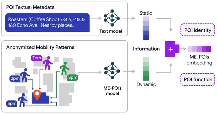
Language models like Gemini build their understanding of a place, whether a business, park or landmark, mostly from static text metadata: addresses, business categories and descriptions. Google Research argues that misses a place's actual functional rhythm, the pattern of when and how people actually use it, and introduces Mobility-Embedded POIs (ME-POIs) to close that gap.
ME-POIs is a self-supervised framework that blends language embeddings from models like Gemini with large-scale, anonymized mobility patterns drawn from public benchmark datasets: arrival times, stay durations and the surrounding movement footprint through the day. A three-step pipeline builds the result. Visit alignment turns a place's temporal arrival, departure and stay patterns into a dense "functional centroid" vector covering a full one-year cycle across different days of the week. Spatial multiscale visit propagation then tackles the long-tail problem: most small businesses, unlike famous landmarks or malls, have too little visit data of their own, so the model statistically transfers the aggregated patterns of busy, data-rich neighbors at the street, block and neighborhood scale to nearby sparse places. Text-mobility synergy finally aligns the language embedding with the new mobility vector by maximizing their cosine similarity, layering operational context (is this a lunch spot or a late-night diner) on top of semantic content (this place sells food).
Google Research evaluated the framework on five downstream tasks across two culturally distinct metro areas, Los Angeles and Houston, testing strictly on places the model had not seen during training. Baselines included text-only embedding models like Gemini embeddings, trajectory-based geospatial models like TrajGPT, and hybrid variants. Integrating ME-POIs with text models produced an up to 81.9% relative gain in predicting visit intent, a 75.1% improvement in price-level classification, and a 24.7% increase in busyness estimation accuracy, consistently beating both purely text-based and purely mobility-based baselines. One finding stood out: in several cases, including price-level classification, a model trained on mobility data alone outperformed one trained on text metadata alone, suggesting collective visiting behavior can describe a place more precisely than its written label.
The post is by Google Research scientists Maria Despoina Siampou and Shushman Choudhury, with co-authors Neha Arora of Google Research, and Professor Cyrus Shahabi and PhD student Shang Ling Hsu of the University of Southern California. The work sits inside Google's broader Google Earth AI effort to turn planetary-scale data into actionable geospatial intelligence. The authors are explicit that ME-POIs works only in aggregate: it cannot draw conclusions about individual users and is not built for personalization. No paper title, publication venue or arXiv link is given, and the post names no product or Gemini feature the framework has shipped into, nor any timeline for one.
Key facts
- ME-POIs blends anonymized mobility data (arrival times, stay durations, surrounding movement patterns) with text embeddings from models like Gemini to represent places.
- On unseen places it delivered up to an 81.9% relative gain in visit-intent prediction, a 75.1% improvement in price-level classification, and a 24.7% increase in busyness estimation accuracy.
- Evaluated on five downstream tasks across Los Angeles and Houston against text-only embeddings and trajectory models like TrajGPT.
- A spatial multiscale propagation mechanism transfers mobility patterns from data-rich neighboring places to fix the data-sparsity problem for small, low-traffic businesses.
- Authored by Google Research scientists Maria Despoina Siampou and Shushman Choudhury with co-authors from Google Research and USC, as part of the broader Google Earth AI effort.
Why it matters
Text-only place representations top out at what is written down: a category, an address, a description. ME-POIs adds the missing functional signal, how a place actually gets used through the day and across the week, by fusing anonymized mobility patterns into the same embedding space as the language model's text representation. That lets a model like Gemini infer things such as opening hours, price level or current busyness without recomputing them from scratch each time, because the pattern is already baked into the place's vector.
Who it affects
This targets teams building geospatial or local-search AI on top of language models: anyone whose system needs to reason about businesses, venues or landmarks beyond what their listing says. It does not target end users directly. The authors stress the framework produces only aggregate signatures of places across broad populations and time frames; it explicitly cannot draw conclusions about individual users and is not designed for personalization.
How to use it
ME-POIs is presented as a research framework, not a shipped product. The post names no pricing, no licence, and no product or Gemini feature it has been integrated into, and gives no timeline for when it might reach production. The underlying mobility data is described only as "publicly available benchmark datasets," without naming which ones.
How solid is it
The framework was tested on five distinct tasks across two large, culturally different metro areas, Los Angeles and Houston, strictly on places withheld from training. It was benchmarked against text-only embedding models like Gemini embeddings, trajectory-based models like TrajGPT, and hybrid variants, with ME-POIs consistently ahead across all tasks. That said, the post gives no individual performance figures for the baseline models, no paper title, no publication venue and no arXiv link, so the claims cannot yet be checked against a peer-reviewed writeup.
Risks and caveats
The reported gains, up to 81.9% for visit intent, 75.1% for price level, 24.7% for busyness, are Google Research's own figures from a blog post rather than a linked, citable paper, and the specific benchmark datasets behind them are not named. The authors are careful to scope the framework to aggregate patterns only, ruling out individual-level inference or personalization by design, but that also means it says nothing about how the underlying mobility data was collected or how representative it is beyond Los Angeles and Houston.
“Our collective actions at a physical place are often far more descriptive than the formal words used to label it.”
— Google Research, ME-POIs blog post