Google unveils planetary prediction engine, cutting modeling from weeks to minutes
On August 27, 2026, Google Research engineers Rama Pasumarthi and Shravya Shetty introduced the planetary prediction engine (PPE), an experimental capability inside the company's Earth AI initiative. Google describes PPE as an autonomous AI system that runs the entire geospatial modeling workflow, from data discovery to model training and evaluation, directly from a natural-language query. The team frames the launch around a practical problem: building high-fidelity geospatial models for public health, food security, environmental risk and socioeconomic tracking normally needs specialized teams that spend weeks on manual data curation, feature engineering and spatial validation. Existing AutoML and LLM-based agents automate standard machine learning pipelines, Google says, but they depend on pre-curated tabular data and lack the specialized ability to handle geospatial workflows on their own, which leaves planetary-scale analytics a bottleneck, especially when a fast response matters during a humanitarian crisis.
PPE breaks the prediction workflow into three modular stages, each one run by a large language model: intelligent geospatial data selection, multimodal dataset curation, and automated model building and prediction. Each stage works from well-defined inputs and outputs to avoid bottlenecks, and data artifacts move between stages as opaque handles rather than being pasted into an LLM prompt, which sidesteps context-window limits. Given a geospatial predictive query, PPE autonomously retrieves the relevant data, engineers features, trains and evaluates candidate models, and produces a full report, without a person doing the data engineering by hand.
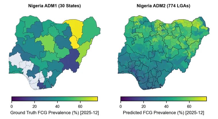
Google evaluated PPE across what it calls a multidimensional matrix of machine learning tasks, geographies and scientific domains, checking it against manual or published baselines rather than against any other AI system. Across 21 CDC health indicators, PPE's data selection and multimodal fusion reached a mean R² of 76.8%, against 60.0% for a manual expert pipeline. It reported similar gains predicting FEMA national risk indicators, 64.9% versus a 60.0% baseline, and the Social Vulnerability Index, 66.2% versus 58.6%. On a task that downscales food-security estimates from state-level (ADM1) data to local-government-area (ADM2) data by pulling in local market shocks, food-price anomalies and microclimate indicators, PPE reached an R² of 66.1% against a 31.5% baseline, which Google describes as doubling the baseline's accuracy. For the 2026 Bundibugyo ebolavirus outbreak in the Democratic Republic of the Congo (DRC), PPE reached a Recall@10 of 83.3%, correctly flagging 15 of the 18 health zones the outbreak newly reached across five sequential weekly forecasts; Google reports this as a 10.3 percentage point absolute improvement over a published state-of-the-art Bayesian modeling baseline of about 73%, driven by fusing epidemiological signals with PDFM embeddings and geospatial covariates PPE selected itself. Separately, in its closing summary Google lists food insecurity in Nigeria, alongside US chronic-disease prevalence and the DRC outbreak work, as one of three domains illustrating PPE's range, and the post explicitly ties that Nigeria mention to the ADM1-to-ADM2 downscaling numbers above, in a section headed Super-resolution downscaling: Nigeria food security.
A finding Google highlights across every experiment is that combining structured statistical covariates with embeddings from its foundation models works better than either alone: statistical covariates give explicit, interpretable signals, while Population Dynamics Embeddings and AlphaEarth Foundations embeddings capture complex, non-linear patterns learned during pretraining. Ablation studies consistently showed that multimodal fusion together with PPE's intelligent data selection beat baseline approaches, which Google takes as evidence the two representations are complementary rather than redundant. The team says future work will add more geospatial data sources and more foundation-model embeddings, including Remote Sensing Foundations multimodal embeddings.
Google is explicit that PPE remains an early-stage research project rather than a released product: the post gives no release date, pricing or general-availability plan. It thanks the UN World Food Programme and its Vulnerability Analysis and Mapping team for data and research support, the Institut National de Recherche Biomédicale (INRB) for collaborating on the DRC Ebola nowcasting work, and the teams behind Data Commons, Google Earth Engine, Population Dynamics Foundation Models and AlphaEarth for the underlying data and model infrastructure. The post also thanks the unnamed co-authors of an underlying paper that is linked via a Quick links entry but not titled anywhere in the announcement.
Key facts
- Google Research introduced the planetary prediction engine (PPE) on August 27, 2026, an experimental part of its Earth AI initiative that autonomously runs the full geospatial modeling workflow, from data discovery to model training, starting from a single natural-language query.
- PPE is built as three modular stages, each run by a large language model, with data passed between stages as opaque handles rather than pasted into prompts, so the pipeline avoids context-window limits.
- Across 21 CDC health indicators, PPE reached a mean R² of 76.8% against 60.0% for a manual expert pipeline; it also beat baselines on FEMA national risk indicators (64.9% vs 60.0%) and the Social Vulnerability Index (66.2% vs 58.6%).
- On a task downscaling food-security estimates from state-level (ADM1) to local-government-level (ADM2) data, PPE reached an R² of 66.1% against a 31.5% baseline, which Google describes as doubling the baseline's accuracy.
- During the 2026 Bundibugyo ebolavirus outbreak in the Democratic Republic of the Congo, PPE reached a Recall@10 of 83.3%, correctly flagging 15 of 18 newly invaded health zones across five weekly forecasts, a 10.3 percentage point absolute gain over the published state-of-the-art Bayesian baseline of about 73%.
Why it matters
Building a high-fidelity geospatial model for public health, food security, environmental risk or socioeconomic tracking normally takes a specialized team weeks of manual data curation, feature engineering and spatial validation. Existing AutoML and LLM-based agents automate standard machine learning pipelines, Google says, but they depend on pre-curated tabular data and cannot handle geospatial workflows on their own, which leaves planetary-scale analytics a bottleneck, and a costly one when a humanitarian crisis calls for a fast response. PPE targets that gap directly: Google reports it cuts the time to build a complex planetary prediction model from weeks of manual engineering to minutes of autonomous work, run from nothing more than a natural-language query.
Who it affects
Google frames PPE for researchers, humanitarian organizations and policymakers who need geospatial predictions without a dedicated engineering team. The post credits the UN World Food Programme and its Vulnerability Analysis and Mapping team for data and research support, and the Institut National de Recherche Biomédicale (INRB) for collaborating on the DRC Ebola nowcasting work. The evaluation domains themselves point at who benefits: US public-health agencies tracking chronic disease (the CDC indicators), disaster-risk and vulnerability mapping (FEMA and the Social Vulnerability Index), food-security monitoring in data-scarce regions, which the post separately names Nigeria as an example of, and outbreak-response teams like the ones handling the DRC's 2026 Ebola outbreak.
How to use it
PPE is not a released product. Google calls it an experimental, early-stage research capability inside its broader Earth AI initiative, and the announcement gives no release date, pricing or general-availability plan. As described, a user gives PPE a geospatial predictive query in natural language, and it autonomously retrieves relevant data, engineers features, trains and evaluates models across its three internal stages, and returns a full report, with no manual data-engineering step in between.
How solid is it
The evidence is Google's own benchmarking across what it calls a multidimensional matrix of tasks, geographies and domains, checked against a manual expert pipeline or a published baseline rather than against any rival AI system. Reported mean R² gains run from a few points (64.9% vs 60.0% on FEMA risk indicators) to close to doubling a baseline (66.1% vs 31.5% on food-security downscaling), and on DRC Ebola-hotspot prediction PPE's Recall@10 of 83.3% beat a published state-of-the-art Bayesian baseline of about 73% by 10.3 percentage points, an absolute gain rather than a relative one. Google also ran ablation studies showing that fusing structured statistical covariates with foundation-model embeddings, Population Dynamics Embeddings and AlphaEarth Foundations among them, consistently beat either approach alone. None of this is independently replicated in the post: the underlying paper is linked but untitled, there is no named venue, and there is no comparison to a non-Google system, so the size of the reported gains rests entirely on baselines Google chose and measured itself.
Risks and caveats
Google repeatedly hedges the claim: PPE is an early-stage research project, and the company says it merely believes the work is a meaningful step toward democratizing geospatial prediction, not that the case is closed. The post names the three internal pipeline stages (intelligent geospatial data selection, multimodal dataset curation, and automated model building and prediction), links but does not title the underlying paper, and thanks unnamed co-authors beyond the two engineers credited on the byline. It also omits dataset sizes, sample windows and evaluation periods for the CDC, FEMA and Social Vulnerability Index comparisons, though it does explicitly connect its Nigeria food-security example to the ADM1-to-ADM2 downscaling numbers it reports elsewhere in the same post, in a section headed Super-resolution downscaling: Nigeria food security.
“We believe this experimental research represents a meaningful step toward democratizing geospatial prediction.”
— Rama Pasumarthi, Staff Software Engineer, and Shravya Shetty, Distinguished Engineer, Google Research