Copernicus Browser adds a free wildfire visualization layer
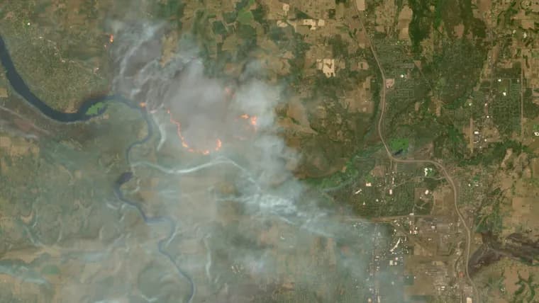
Copernicus Browser, the European Union's free public viewer for imagery from the European Space Agency's Sentinel satellites, added a new "wildfires" visualization layer for Sentinel-2 imagery on August 4. The three Sentinel-2 satellites already supported wildfire monitoring by capturing multi-spectral images at resolutions as fine as 10 meters in the visible light and near-infrared bands, and Copernicus Browser previously offered 10 default visualization layers built from different combinations of those spectral bands. The new layer joins that existing set: click it over a wildfire location and active fires show up white or yellow, burning vegetation shows up red, and already burned landscape shows up dark brown or black.
The layer packages a script written in JavaScript by remote sensing expert Pierre Markuse, which the article says originates from nearly a decade ago. According to Geovisualization, which the article cites for the technical explanation, Markuse's script combines three inputs: the red visible light band, the narrow near-infrared band, which highlights the difference between healthy and burned vegetation, and the short-wave infrared 2 band, which reveals burned landscape by picking up soil moisture levels. Copernicus Browser has now turned that combination into a single selectable layer instead of requiring users to build it themselves.
Key facts
- Copernicus Browser, the EU's free satellite imagery viewer, added a "wildfires" visualization layer for Sentinel-2 imagery on August 4.
- The layer colors active fires white or yellow, burning vegetation red, and burned landscape dark brown or black.
- It packages a script written by remote sensing expert Pierre Markuse, which the article says dates back nearly a decade.
- The script combines the red visible light band, the near-infrared band and the short-wave infrared 2 band to separate fire, vegetation and burned soil.
- Sentinel-2's three satellites image at resolutions as fine as 10 meters in visible light and near-infrared bands, and the browser previously offered 10 default visualization layers before this addition.
Why it matters
Reading wildfire damage from raw satellite imagery normally means manually combining spectral bands, a task for people with remote sensing training. By baking Pierre Markuse's band combination into a single default layer, Copernicus Browser turns that expert workflow into a one-click option on a service that is already free and open to anyone, not just specialists with the know-how to build custom band combinations themselves.
Who it affects
The article frames the beneficiary broadly: "anyone" using Copernicus Browser to look at a wildfire location. It does not name specific user groups such as emergency services or newsrooms, so the retelling stays with what the source states: free, public access to the new layer for whoever opens the browser.
How to use it
Open Copernicus Browser, navigate to Sentinel-2 imagery of a wildfire location, and select the new wildfires layer from the visualization options, where it joins the 10 default layers already on offer. No cost and no manual band-combination setup are required; the layer does the combining automatically.
How solid is it
The underlying data comes from an established, operational program: the European Space Agency's Sentinel-2 mission and its three satellites, feeding the EU's free Copernicus Earth observation service. The visualization technique itself is not new, Markuse's script is described as originating nearly a decade ago, and the article attributes its technical breakdown to Geovisualization rather than to Markuse directly.
Risks and caveats
The article does not name a specific wildfire event the new layer has been used on, does not give the year for the stated August 4 launch date, and carries no author byline. It is also worth noting this is an interface addition rather than a new sensing capability: it packages an existing, years-old technique into an easier default layer rather than adding any new ability to detect fire.