Google and NASA JPL's MAPL-EMIT spots methane plumes from space with 84% recall
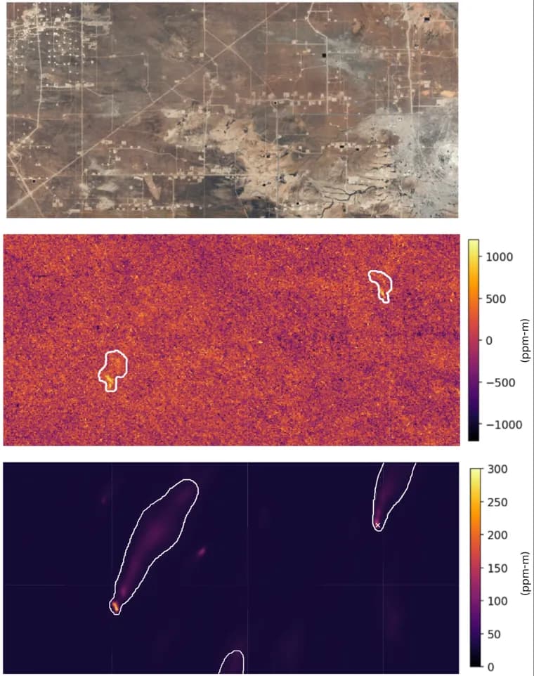
Google Research and scientists at NASA's Jet Propulsion Laboratory have published a deep-learning system called MAPL-EMIT (Methane Analysis and Plume Localization with EMIT) that automates the detection, enhancement quantification and source estimation of methane plumes from satellite data, described in a paper in the Proceedings of the National Academy of Sciences (PNAS) and posted to the Google Research blog on September 1, 2026 by Vishal Batchu, a Research Engineer, and Michelangelo Conserva, a Research Scientist, both at Google Research.
The system runs on data from NASA's Earth Surface Mineral Dust Source Investigation (EMIT) instrument, a hyperspectral imager mounted on the International Space Station that was originally built to map mineral composition in arid regions. EMIT records hundreds of distinct light bands per pixel, letting researchers pick out the chemical fingerprint of methane, an otherwise invisible gas whose warming potential is 30 times greater than carbon dioxide's over a 100-year timeframe and which has driven about 25% of human-induced warming since the industrial era began. More than 125 countries have committed to a 30% cut in methane emissions by 2030 under the Global Methane Pledge, a target that depends on tracking point sources, emissions from a small footprint of a few tens of meters, across oil and gas, agriculture and waste sites.
Measuring methane from orbit means trading off field of view, spatial resolution and spectral resolution. Global mappers like TROPOMI cover a wide swath, about 2,600 km, at coarse spatial resolution (around 5.5 km by 3.5 km) but fine spectral sampling (0.1 nm), which suits tracking background concentration changes. EMIT instead covers an 80 km wide field of view at a much sharper 60 meter spatial resolution and a moderate 7.4 nm spectral resolution, tuned for measuring emissions at individual facilities. Turning that raw hyperspectral data into a usable global map is harder than it sounds: many surface materials mimic methane's spectral signature, and in dense industrial areas, plumes from separate nearby facilities often blend into a single cloud.
MAPL-EMIT tackles this with an end-to-end vision transformer built on a Swin-S architecture, part of Google's broader Google Earth AI effort. Rather than classifying methane pixel by pixel, as many prior methods do, it processes the full spectrum together with its surrounding spatial context, which helps it tell a genuine wind-blown plume apart from ground that merely looks similar spectrally. The model solves three tasks at once so it can untangle scenes where multiple sources overlap.
Training a transformer this way needs far more labeled real-world plumes than exist, so the team built a physics-based simulation pipeline instead. They generated 3.6 million synthetic methane plumes and injected them into real EMIT scenes, using Lagrangian puff models, which simulate how particles disperse through turbulent air, to reproduce realistic plume behavior across varied atmospheric and geographic conditions.
Benchmarked against NASA's gold-standard L2B methane plumes dataset across roughly 1,100 EMIT granules, MAPL-EMIT captured 84% of expert-annotated plumes and identified around 50% more plausible plumes than the reference dataset, while also detecting weaker emissions than current methods reach. In a real-world test, it successfully mapped plumes at 24 of the world's 25 top-emitting landfills. The authors say false positives remain an ongoing challenge, especially over complex terrain, so each detection ships with a physics-based plume confidence score plus a simple 'lower' or 'higher' confidence tag, letting users tune the trade-off between catching real plumes and tolerating false alarms.
Google and NASA JPL are releasing the global plume database and an interactive Earth Engine App for public use, along with the trained model and the synthetic training plumes on Kaggle and an inference library on GitHub. The authors note NASA is preparing to launch next-generation imaging spectrometers that will increase coverage by a factor of 30 to 50 times over current instruments, which they frame as raising the stakes for automated tools like MAPL-EMIT to keep pace.
Key facts
- MAPL-EMIT is a vision transformer (Swin-S) built by Google Research with NASA JPL that detects, quantifies and localizes methane plumes from EMIT hyperspectral satellite data; described in a PNAS paper.
- It achieves 84% recall on expert-annotated plumes and identifies around 50% more plausible plumes than NASA's gold-standard L2B dataset across roughly 1,100 EMIT granules.
- Training relied on 3.6 million synthetic methane plumes generated with Lagrangian puff models and injected into real EMIT scenes, since a large labeled real-world dataset does not exist.
- The model successfully mapped plumes at 24 of the world's 25 top-emitting landfills, though false positives remain a challenge in complex terrain, addressed with confidence scoring.
- Google and NASA JPL are releasing the global plume database, an Earth Engine App, the trained model, synthetic plumes on Kaggle, and an inference library on GitHub.
Why it matters
Methane traps roughly 30 times more heat than carbon dioxide over a century and has driven about a quarter of human-caused warming so far, but its short atmospheric lifetime makes cutting it one of the fastest levers available against near-term warming. Over 125 countries have pledged a 30% reduction by 2030 under the Global Methane Pledge, a target that hinges on being able to find and measure point-source leaks, from oil and gas sites, farms and landfills, at facility scale and globally, not just as background atmospheric trends. MAPL-EMIT is aimed squarely at that gap: turning EMIT's hyperspectral imagery into an automated, scalable pipeline for spotting and quantifying individual plumes rather than requiring manual expert review.
Who it affects
The releases target the scientific community, environmental researchers, local stakeholders, policymakers and industry operators who need to locate and act on emissions sources. Companies operating oil and gas infrastructure, landfills and agricultural facilities are direct subjects of the detection work; regulators and NGOs pursuing the Global Methane Pledge's 2030 target are the intended users of the resulting data. The work is a joint effort between Google Research (Vishal Batchu and Michelangelo Conserva are credited as the post's authors) and NASA's Jet Propulsion Laboratory, which operates the EMIT instrument on the International Space Station.
How to use it
Everything is released for public use rather than sold: the global plume database is published on Google Earth Engine along with an Earth Engine App for interactive visualization, the trained model and the 3.6 million synthetic training plumes are available on Kaggle, and an inference library is posted on GitHub. Each detected plume carries a physics-based confidence score plus a simplified 'lower' or 'higher' confidence tag, letting users calibrate how aggressively they want to trade off catching real plumes against tolerating false positives for their own application.
How solid is it
The headline figures come from a peer-reviewed PNAS paper: 84% recall against expert-annotated plumes and about 50% more plausible plumes identified than NASA's own gold-standard L2B methane dataset, measured across roughly 1,100 EMIT granules, plus a real-world validation mapping plumes at 24 of the world's 25 top-emitting landfills. The model's core innovation, a vision transformer that reasons over spatial context rather than classifying pixels independently, was trained on a physics-based synthetic dataset of 3.6 million plumes built with Lagrangian puff models precisely because comparably large labeled real-world data does not exist, a design choice the authors argue lets the model generalize across atmospheric and geographic conditions that real data alone would not cover.
Risks and caveats
The authors state plainly that false positives remain an ongoing challenge, particularly in complex terrain, which is why every output is paired with a confidence score rather than treated as a clean binary detection. The source does not disclose which one of the 25 top-emitting landfills was missed, does not give cost, funding or compute figures for building the model or the synthetic-plume pipeline, and does not state when the PNAS paper was submitted versus published. NASA's next-generation imaging spectrometers, expected to boost coverage 30 to 50 times over current instruments, are described only as being in preparation, with no launch date given, meaning the scale-up MAPL-EMIT is built to anticipate has not yet arrived.
“As with many highly sensitive models, false positives remain an ongoing challenge, particularly in complex terrain.”
— Google Research blog post