Google expands access to Geospatial Reasoning agent built on Earth AI and Gemini
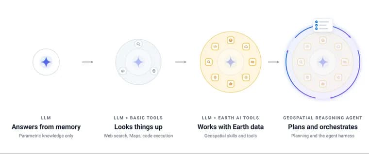
On October 14, 2026, Google Research published a technical report and blog post, written by Shravya Shetty (Distinguished Engineer) and Luke Barrington (Product Director), on its Geospatial Reasoning agent. The authors say that combining domain-specific foundation models, spatial tools and an upfront planning stage lets the agent carry out complex spatial analysis and planetary prediction that standalone LLMs cannot. After what they call promising tests with partners, Google is expanding experimental access through Ask Google Earth and an Agent-to-Agent (A2A) service.
The agent grows out of the earlier Google Earth AI work, which introduced geospatial foundation models covering remote sensing, weather, flood hydrology and population dynamics, plus a prototype Gemini agent. Google now describes it as a much more capable, experimental system built for multi-step geospatial reasoning across planet-scale data and for autonomous training of custom predictive models. Google's argument is that general-purpose LLMs and standard coding tools struggle with real spatial problems, because planetary datasets are massive and come in specialised map and satellite formats that need careful multi-step planning to combine accurately.
The agent connects Gemini to Earth AI models including WeatherNext, Flood Forecasting, the Population Dynamics Foundation Model (PDFM), AlphaEarth Foundations and Remote Sensing Foundations. It also draws on Google Maps Platform (place information, routing, air quality, rooftop solar potential), Google Earth Engine, Data Commons and Google Dataset Search. These capabilities are packaged as modular skills that the agent calls only when a question needs them. Before running complex operations it builds a step-by-step plan, picks fallback datasets when local coverage is sparse, and processes large map layers in a dedicated workspace, which keeps massive spatial data out of the agent's context while preserving accuracy and data attribution. Every response shows the plan and the data sources, so experts can check assumptions or substitute datasets.
Users can now bring their own data through the agent API as CSV spreadsheets, GeoJSON custom map boundaries or cloud tables, and ask the agent to join their private locations with Earth AI's global models and catalogs. The agent also powers the recently announced Planetary Prediction Engine. Given a user's local outcome data, such as regional disease rates, crop yields or grid outages, it selects relevant population and environmental signals, fuses Population Dynamics Insights and Custom Satellite Embeddings (Google Maps Platform products built on PDFM and AlphaEarth Foundations), and trains validated machine learning models for spatial prediction, super-resolution downscaling and forecasting. In Google's recent public health research, combining these population and satellite signals improved predictions of health outcomes by 12% over demographic baselines and enabled mapping at 8X finer spatial resolution.
The technical report compares four agent configurations across Gemini 3.8 Flash and Gemini 3.1 Pro: a standalone LLM; the LLM with basic web search and maps grounding; the LLM with Earth AI tools such as Remote Sensing Foundations and WeatherNext 3 but no upfront planning; and the full agent, which begins every query with a dedicated planning stage that assesses what it can and cannot do and sets out the retrieval and processing steps. Evaluation spans four benchmarks. CBGB (geospatial code generation) and UnivEARTH (question answering) were developed externally. Google built two new ones: GeoExpertQueries, with complex real-world queries and expert-authored golden workflows in areas like crisis resilience, site selection and public health, and GeoKTools, with templated queries whose verifiable answers each require correct use of 1 to 4 distinct geospatial tools. Google releases the development splits of both new benchmarks in full.
Two takeaways follow. First, domain-specific skills are essential: the agent with only basic tools struggles on quantitative spatial tasks, and Earth AI skills drive a significant jump on GeoExpertQueries, GeoKTools and CBGB. The exception is UnivEARTH, where even a standalone LLM scores 93.6%, likely because the source NASA articles and answers are on the public web. Second, upfront planning unlocks open-ended workflows: Earth AI skills alone suffice for narrower tasks like CBGB and GeoKTools, but GeoExpertQueries needs planning to keep the agent on track and stop it making unreliable assumptions or taking shortcuts such as using web search instead of spatial tools.
The report also covers limitations. GeoExpertQueries scores come from an autorater that compares the agent's performance to expert workflows that define the steps an analysis should take, not the correct final answer. Google therefore treats the output as a strong first draft for experts to review and build on, not a final answer.
A small group of partners tested the agent on public health, disaster response and infrastructure planning problems. Their feedback drove recent additions of road-network routing, support for larger user-uploaded datasets and better discovery of authoritative local data sources. Google is now making the capabilities available to a limited group of early users, with Planetary Prediction Engine features in early preview through an interactive plain-language interface and the Agent API. Interested users can fill in an interest form or join the Early Access Pool.
Key facts
- Google Research's experimental Geospatial Reasoning agent combines Gemini with Earth AI models (WeatherNext, Flood Forecasting, PDFM, AlphaEarth Foundations, Remote Sensing Foundations), Google Maps Platform, Earth Engine and Data Commons, and begins every query with a planning stage.
- The technical report compares four configurations across Gemini 3.8 Flash and Gemini 3.1 Pro on four benchmarks: CBGB, UnivEARTH, and two new Google-built ones, GeoExpertQueries and GeoKTools.
- Earth AI skills give a significant jump on GeoExpertQueries, GeoKTools and CBGB; on UnivEARTH a standalone LLM already scores 93.6%, likely because the source NASA material is on the public web.
- The agent powers the Planetary Prediction Engine, which trains models from a user's local outcome data; Google's public health research reports a 12% improvement over demographic baselines and 8X finer mapping.
- Access is expanding to a limited group of early users via Ask Google Earth and an A2A service, and Google releases the development splits of GeoExpertQueries and GeoKTools in full.
Why it matters
Geospatial questions mix huge datasets, specialised map and satellite formats and multi-step analysis, which Google says general-purpose LLMs and standard coding tools handle poorly. This report is Google's attempt to show that the gain comes from three things together: domain-specific models, spatial tools and a planning stage before any work starts. The finding that planning matters most for open-ended problems, while skills alone are enough for narrow tasks, is a useful design lesson for anyone building agents on specialised data. Releasing the development splits of two new benchmarks also gives other researchers something to test against.
Who it affects
The immediate audience is the limited group of early users getting experimental access, and organisations that hold their own location data, such as regional disease rates, crop yields or grid outages, and want models trained on it. The partners tested the agent in public health, disaster response and infrastructure planning. Researchers working on geospatial agents can use the released development splits of GeoExpertQueries and GeoKTools.
How to use it
Access is limited and experimental. Google points to Ask Google Earth and an Agent-to-Agent (A2A) service, and says Planetary Prediction Engine capabilities are in early preview through an interactive plain-language interface and the Agent API. Through the agent API, users can upload CSV spreadsheets, GeoJSON custom map boundaries or cloud tables and ask the agent to join them with Earth AI's global models and catalogs. To request access, Google asks people to complete an interest form or sign up for its Early Access Pool.
How solid is it
This is a first-party report from Google Research, and the benchmark results are Google's own; two of the four benchmarks were developed by Google. No independent evaluation or third-party reaction is reported. The scores table for Gemini 3.8 Flash is not in the text available here, so the only agent figure that can be cited is the 93.6% for a standalone LLM on UnivEARTH. The 12% and 8X figures come from Google's own public health research, and the source does not say which health outcomes, region or baseline model. The partners are not named and their results are not described in detail.
Risks and caveats
Google itself calls the system experimental and treats its output as a strong first draft for experts to review, not a final answer. GeoExpertQueries scores come from an autorater that compares the agent's work to expert workflows rather than to a correct final answer. UnivEARTH shows little difference because a standalone LLM already scores 93.6%, which Google attributes to the source material being publicly available. No dates, pricing, regions or general-availability timeline are given for the early access or the preview.
“We therefore consider the agent’s output as a strong first draft for experts to review and build on, not a final answer.”
— Shravya Shetty and Luke Barrington, Google Research